Protecting wildlife and ecosystems with data-driven insights

$0
850+
conservation sites
23K
150+
Helping to make a difference, worldwide
Photo credit: Nicolás Lagos / Panthera
Photo credit: Conflict Islands Conservation Initiative
Photo credit: Scott Ramsay / WCS
Photo credit: Matt Curnock / Ocean Image Bank
Photo credit: African Parks / Marcus Westberg

Photo credit: Nicolás Lagos / Panthera
Ecoscope


Integrations

With you every step of the way.
Your data stays yours. EarthRanger provides configurable access, encryption, and industry-leading security at every step.
Leverage AI-driven integrations and cutting-edge satellite services alongside your field observations, sensors, GPS devices, and third-party tools–all in one place to save time, maximize resources, and act with confidence.
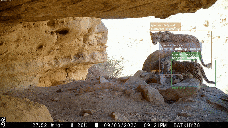
Image credit: Team Bars Turkmenistan/MoEPT/CXL
Secure, optional data sharing supports coordination across protected areas and landscapes–without compromising control.
EarthRanger connects teams with real-time updates and a shared landscape view, keeping everyone aligned, wherever they are.
Photo credit: USAID Greening Prey Lang
Collect observations offline, and EarthRanger syncs your data automatically when a connection is restored.
Record precise data in the field using GPS coordinates, polygons, photos, and notes—not just capturing where but also how much, what, and potentially why.
Track wildlife, vehicles, aircraft, and personnel whether you’re in the field or behind a computer.
Photo credit: Keith Begg / Niassa Lion Project
Keep an eye on your teams and send messages directly through EarthRanger to coordinate and respond when it matters most.
Receive SMS, WhatsApp, or email alerts when key movement patterns–like immobility, speed changes, or boundary crossings–are detected, turning data into real-time insight.
Heat maps, time slider, and real-time updates from the field bring your landscape to life, revealing patterns that guide your next steps.
Easily visualize past patrols, surveys, and events to identify trends and strengthen future strategies.
Use base layers, terrain maps, and overlays to assess where teams have been and where to focus next.
Advancing conservation in 80 countries
Latest news
- Ecological Management
- Human Wildlife Conflict
- Security
.jpg)
- Ecological Management
- Human Wildlife Conflict
- Security

"EarthRanger has become our indispensable lifeline, enabling a fully paperless workflow that has transformed our operations and magnified our conservation impact."
–Hayley Versace, General Manager at Conflict Islands Conservation Initiative
Upcoming events